E-mail: contact us
![[MapQuest map]](../maps/map-mapquest_356x309.gif)
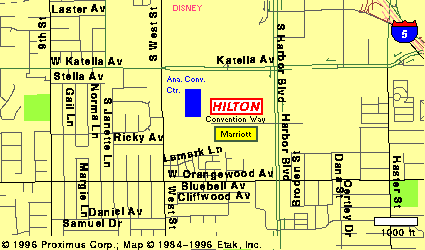
There are plenty of mapping services online. If you click on this map,
you should get an uncorrected version from MapQuest's website.
There are a few slight errors with most of the online mapping databases. The online maps show "Convention Way" as continuing west all the way to West Street, which is misleading -- it's blocked off in the front of the convention center. Similarly, the unnamed street that connects Katella and Convention Way has been turned into a pedestrian walkway, and the only motor vehicles allowed through is the city's tram service. We've shown both of those access roads as dotted lines at left. Hotel Way still runs along the east side of the Hilton, connecting Katella and Convention Way,
As a public service, we have these map graphics for your use. They've been updated (by your webmaster), to show the current street situation, even though some of them still bear an older copyright date.
This partial list and sample maps are provided for your information.
L.A.con IV does not endorse or recommend any particular
mapping service.
From our convention site in Anaheim, Fullerton is to the north; Orange is to the east and southeast; Garden Grove is to the south and the west.
Note that the block numbering is different for each city. An extreme example can be found on Chapman Ave., where if you proceed from Harbor Blvd. eastward you have Garden Grove on your right, but on the left you pass through Anaheim (3-digit numbers decreasing eastward), Garden Grove (5-digit numbers increasing eastward), and Orange (4-digit numbers decreasing eastward). Also some portions of Anaheim, mostly on the Garden Grove border, use the same 5-digit county numbering system Garden Grove uses.
Anaheim's center point is the intersection of Lincoln and Anaheim Blvd. (Our site is southwest of that point.) Fullerton's is Commonwealth and Harbor. Orange's is at Chapman and Glassell, aka Orange Plaxza. Garden Grove doesn't have a "center;" it uses the county numbering system. Those numbers increase southward and eastward.
The major thoroughfares in northern Orange County usually run N-S & E-W, with the major streets at 1 mile intervals. There are typically semi-major streets halfway between an adjacent pair of majors. Near downtown Anaheim, the whole map gets about a 15 degree rotation counter- clockwise. (This was to align the streets of the original colony with the railroad; it evidently seemed like a good idea at the time.) Also, some of the major north-south thoroughfares get "adjusted" as they approach Garden Grove Blvd. (Thus, north of GG Blvd., Harbor & Euclid are 1 mile apart. Heading southbound on each, as one approaches GG Blvd., one swerves about 0.25 mi. east on Harbor, and about the same distance west on Euclid. Weird.) Whether or not a given semi-major street may be used to cross a freeway is iffy, at best. The major streets may generally be used thus.
![[1999 Restaurant Guide Map]](../pix/eatsmap3.gif) Click for larger size.
This map was created for our
1999 NASFiC, Conucopia.
Click for larger size.
This map was created for our
1999 NASFiC, Conucopia.
![]()
![[Orange County Bikeways]](../maps/map-bikeways_275x267.gif)
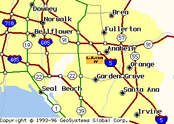
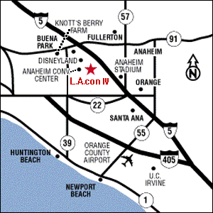
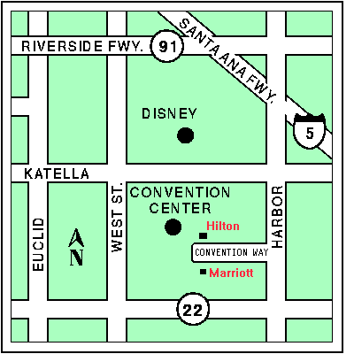
The first map shows Orange County's bike trails - click on map for a larger image,
or see
Orange County Bike Map
![]() for a zoomable PDF file of the map.
The other three maps show the approximate location of our site,
in relation to the freeways of Southern California.
for a zoomable PDF file of the map.
The other three maps show the approximate location of our site,
in relation to the freeways of Southern California.
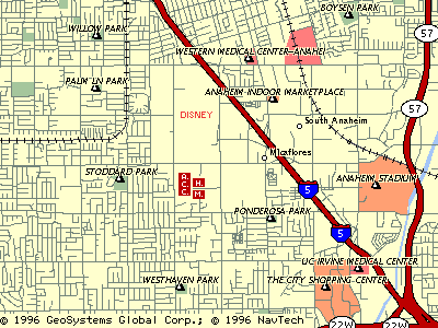
![[Anaheim Resort Transit Map]](../maps/map-artbus_320x270.jpg) The first two maps were obtained online and recently revised.
The third map is
from the
Anaheim Resort Transit
The first two maps were obtained online and recently revised.
The third map is
from the
Anaheim Resort Transit